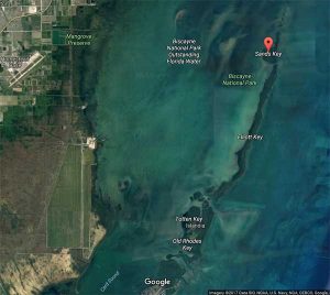
 Sands Key is an island north of the upper Florida Keys in Biscayne National Park. It is in Miami-Dade County, Florida. It is located in lower Biscayne Bay, between Elliott Key and Boca Chita Key.
Earlier names for the island were “Las Tetas”, “The Paps”, “Pownal Kay”, “Pownall Island”, “Restinga de Las Tetas” and “Saunder’s Key”.
“Las Tetas” is Spanish for “breasts”. The island was most likely called this due to two hills, perhaps Indian mounds located there. Bahamians referred to the island as “Saunder’s Key”.
Visited by Bernard Romans in 1774, who wrote that the key was called Las Tetas, or the paps. Romans said that this was due to two hills (probably Indian mounds) on the island. He further noted that the Bahamians called the island Saunder’s Key. Norie, in his Piloting Directions for the Gulf of Florida, Bahama Banks, & Islands (1828) states: “Next to the northward of Elliot’s Kay is a little island, having two small hills on it, whence the Spaniards have called it Las Tetas, or The Paps.”
Alaña chart (1743) shows Restinga de las Tetas (SP. “Sandbank of the Tits”). William Roberts, in his “First Discovery and Natural History of Florida” (1763) uses Las Tetas. O-Carrol chart (1776) also shows Restinga de las Tetas. DeBrahm (1772) shows Pownall Islands. Romans chart (1774) noted that the Bahamians called the island Saunder’s Key. J.W. Norie, in his Piloting Directions for the Gulf of Florida, Bahama Banks, & Islands (1828) states: “Next to the northward of Elliot’s Kay is a little island, having two small hills on it, whence the Spaniards have called it Las Tetas, or The Paps; but by the English, it is called Pownal Kay.” The Bache Coast Survey of 1861 uses Sands Key. A survey map drawn by M.A. Williams in 1872 shows Sands Key.
Sources:


