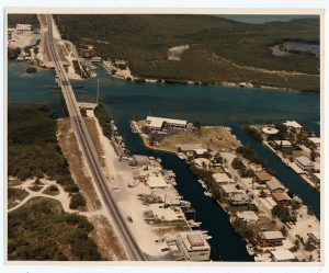
Aerial of the USCG Station on Plantation Key. Photo taken by the Federal Government on October 7, 1987. From the Wright Langley Collection.
The population was 163 at the 2010 census. Located on the shore of Chokoloskee Bay near the north-west end of Everglades National Park. It is bordered to the west by Everglades City.
According to the United States Census Bureau, the CDP has a total area of 0.58 square miles, of which 0.012 square miles, or 1.90%, is water. All of the keys is within the Village of Islamorada as of November 4, 1997. Tavernier Creek (Mile Marker 91.0) separates it from Key Largo by at its Northeast end, and from Windley Key by Snake Creek (Mile Marker 85.5) at its Southwest end.
Plantation Key was inhabited by Native Americans at least 1,000 years before European contact. Large Indian mounds have been located towards the northeastern end of the key. Several artifacts found at those sites were dated to 500 to 700 A.D. They no longer exist since 1958 when they where leveled to allow the development of a real estate subdivision. An early settlement on the Oceanside was known as Pearl City; it is believed to be named Pearl City for some pearls found inside conchs.
Bahamians began settling on Plantation Key in the middle of the 19th Century, and two families were recorded on the key in the 1870 census. By 1880, several more families had moved in. The settlers raised coconuts and pineapples. The pineapples were shipped by schooner to northern U. S. ports as far away as Baltimore and New York City. During this time Florida supplied most of the U.S. but the Florida East Coast Railway began shipping pineapples from Cuba at much lower prices, many of the growers in the Keys could not compete.
To the dismay of Prohibitionist, Prohibition brought new industry to Plantation Key, as its close proximity to the Bahamas made Plantation Key, convenient landing places for bootleggers and smugglers.
Unnamed on Spanish charts. Most early Spanish cartographers considered Plantation Key part of Key Largo. DeBrahm chart (1772) shows Bull Isle. Gauld-Faden chart (1775) shows Long Island. J.W. Norie, In his “Piloting Directions for the Gulf of Florida, the Bahama Banks, & Islands” (1828) states: “This island has no name given to it, either by the Spaniards or the Providence people, but goes under the general appellation of Cayo Largo (Long Key), from which it is separated by a narrow channel; (Tavernier Creek) it is distinguished in our chart by the name of Long Island.”
Blunt chart (1846) shows Long Island. Gerdes, in his “Reconnaissance of the Florida Reefs and All the Keys” (1849) states: “The island below Cayo Largo now called on chart Long Id. is called Plantation Island for the fact of there having formerly been here a plantation belonging to English wreckers from Abaco Island.” A survey map drawn by M.A. Williams in 1872 shows Plantation Key.
Before the Flagler railway crews filled Little Snake Creek, which crossed at a point around today’s Treasure Harbor, the south-west end of Plantation Key was a separate island known as Snake Creek Key.
The historical names include Bull Isle, Long Island, Plantation Island and Snake Creek Key.