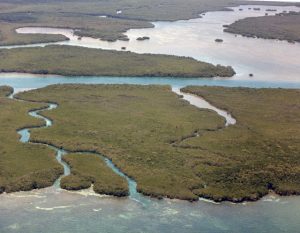
 The Rubicon Keys are two small islands in close proximity to each other north of the Upper Florida Keys in Biscayne National Park and on the south side of Caesar Creek. They are in Miami-Dade County, Florida. The Rubicon Keys are considered mangrove keys.
They are located in southern Biscayne Bay, just north of Old Rhodes Key and Totten Key, and just east of the southern tip of Elliott Key. They are on the south side of Caesar Creek, the creek that separates Elliott and Old Rhodes Keys.
The Rubicon Keys are located at latitude 25.3962237 and longitude coordinates of -80.2436627 at an elevation of zero feet. The topological map of Rubicon Keys is drawn on and part of the United States Geological Service (USGS) area map of Elliott Key.
The Rubicon Keys were named by early U.S. Coast & Geodetic Survey crews after the story of Julius Caesar crossing the Rubicon River in Italy.The Bache Coast Survey of 1861 so names these keys. So named on U.S. Coast & Geodetic Survey chart #1249 (1937).
Fishing enthusiasts should always contact the local Department of Natural Resources for detailed information about the area and to learn about and fee’s or regulations imposed on the area.


