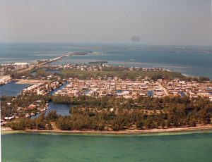
Aerial of Lower Matecumbe Key. Photo taken by the Federal Government on October 7, 1987. From the Wright Langley Collection.
All of the keys are in the Village of Islamorada as it was incorporated in November 4, 1997. Home to the main base of the Florida National High Adventure Sea Base.
This key is the site of a number of Indian mounds and middens, most of which were destroyed during the building of the Overseas Railroad. A number of natural wells were also located here, at the northeast end of the key. These wells were well known to early seafaring men as the most reliable source of fresh water in the Keys. They, too were destroyed during the railroad era, and the location of their site has been lost. The southwestern end of the key is the site of a former sand mining operation.
Historical names include Matacombe la Viega, Matecumbe (el/la) Viejo, Matecunbe lo Viejo, Matecunbe Nuebo, Old Matecumbe, South Matacumbe Key and Vieja Matacomb. The exact meaning of the word Matecumbe is debated but mostly unknown.
Lower Matecumbe was first surveyed by Charles Smith on November 20, 1872. The name Hurricane Harbor was in use in 1877, this area is known as Safety Harbor today.
The natives in the area where described as being large and the women well-proportioned with good countenances. The men wore breechclouts woven of palm while the women cover themselves with Spanish Moss. Their diets consisted of fish, turtle, mollusks, tunny, whale and probably seals. Other animals that made up their diet may have included Florida lobster or crawfish, the chapinor trunk fish, Deer, bear and possibly racoon. The Key Indians according to some historical documents, were said to be great archers and dart throwers.
Lower Matecumbe is home to the most natural of the beaches in the Florida Keys. Sea Oats Beach was known in its earliest years to have many conch and bonefish and provided a wonderful area for all to enjoy. Anne’s Beach (located at mile marker 74 on the east side (oceanside) of the roadway) also located on Lower Matecumbe which was donated to the village by environmentalist Anne Eaton. It provides not only for locals, but visitors alike a scenic boardwalk and the opportunity to enjoy both nature on the shore and the surrounding waters.